Geozonen aus einer CSV-Datei importieren
Wenn Sie Hunderte von Standorten haben, wie z. B. jede Filiale einer Kette oder jeden Abholpunkt, ist es nicht realistisch, sie einzeln auf der Karte zu platzieren. Importieren Sie sie stattdessen aus einer Tabelle.
Die Datei vorbereiten
Anchor link toDie Datei benötigt eine Kopfzeile und eine Zeile pro Standort und darf 5 MB nicht überschreiten. Das bietet Platz für Zehntausende von Standorten, weit mehr, als eine einzelne Geozonen-Kampagne abdecken soll. Drei Spalten sind erforderlich.
In der Datei können Sie kurze Kopfzeilen wie range oder cooldown verwenden. Auf dem Bildschirm Geozonen importieren verwendet das Zuordnungs-Dropdown die unten stehenden Bezeichnungen (zum Beispiel range → Reichweite, m).
| Spalte in der Datei | Wird zugeordnet zu | Erforderlich | Hinweise |
|---|---|---|---|
| Name | Name | Ja | Bis zu 64 Zeichen. |
| Latitude | Latitude | Ja | Zwischen -90 und 90. |
| Longitude | Longitude | Ja | Zwischen -180 und 180. |
| Range | Reichweite, m | Nein | Meter, zwischen 50 und 100.000. Fällt auf Standardreichweite, m zurück. |
| Cooldown | Cooldown, s | Nein | Sekunden, zwischen 60 und 3.596.400 (41 Tage). Fällt auf Standard-Cooldown, s zurück. |
| Message | Nachricht | Nein | Push-Text, bis zu 1024 Zeichen. |
| Cluster code | Cluster-Code | Nein | Ein bestehender Cluster-Code. |
| Preset code | Preset-Code | Nein | Ein bestehender Preset-Code. |
Jede Geozone benötigt etwas zum Senden, daher muss jede Zeile entweder eine Nachricht oder ein Preset enthalten. Dies kann aus der eigenen Spalte der Zeile oder aus Nachricht für jede Zone / Preset für jede Zone auf dem Importbildschirm stammen. Ein Preset hat Vorrang, wenn eine Zeile beides hat.
Beispiel-CSV
Anchor link toHier ist eine geozones.csv mit zwei Standorten. Die zweite Zeile lässt range leer, sodass Standardreichweite, m angewendet wird:
| name | latitude | longitude | range | message |
|---|---|---|---|---|
| Store Downtown | 40.7128 | -74.0060 | 200 | Welcome to our store! |
| Pickup Point | 51.5074 | -0.1278 | Your order is ready |
Darstellung von geozones.csv im reinen Textformat:
name,latitude,longitude,range,messageStore Downtown,40.7128,-74.0060,200,Welcome to our store!Pickup Point,51.5074,-0.1278,,Your order is readyWie man importiert
Anchor link toBefolgen Sie diese Schritte, um die Datei hochzuladen und die Geozonen zu erstellen.
- Klicken Sie auf der Seite Geo-Kampagnen auf CSV importieren. Der Bildschirm Geozonen importieren öffnet sich.

-
Wählen Sie Ihre CSV-Datei aus.
-
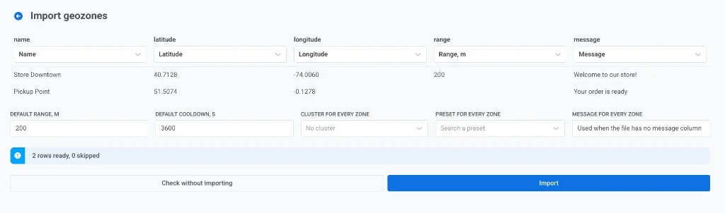
Ordnen Sie Spalten zu und legen Sie Standardwerte auf dem Bildschirm Geozonen importieren fest.
Ordnen Sie jede CSV-Spalte einem Geozonen-Feld zu. Öffnen Sie unter jeder Spaltenüberschrift das Dropdown-Menü und wählen Sie das Feld, das diese Spalte füllen soll:
- Wenn Pushwoosh die Kopfzeile falsch zugeordnet hat, wählen Sie das richtige Feld im Dropdown-Menü aus.
- Setzen Sie eine Spalte auf Nicht importieren, um sie zu ignorieren.
- Ordnen Sie mindestens Name, Latitude und Longitude zu.
- Ordnen Sie Reichweite, m, Cooldown, s, Nachricht, Cluster-Code oder Preset-Code zu, wenn diese Spalten in der Datei vorhanden sind.
Legen Sie Standardwerte für Werte fest, die die Datei nicht liefert:
- Standardreichweite, m und Standard-Cooldown, s. Wird verwendet, wenn die Datei keine Reichweiten- oder Cooldown-Spalte hat oder die Zelle leer ist (wie bei “Pickup Point” im Beispiel).
- Cluster für jede Zone. Wählen Sie einen Cluster oder lassen Sie Kein Cluster stehen.
- Preset für jede Zone. Optionales Push-Preset für jede Zeile, die eines benötigt. Scrollen Sie durch die Liste, um alle Presets der App zu erreichen, und ändern Sie ihre Reihenfolge mit der Sortierschaltfläche neben dem Feld.
- Nachricht für jede Zone. Wird verwendet, wenn die Datei keine Nachrichtenspalte hat. Zeilen, die bereits eine Nachricht haben, behalten ihren eigenen Text.
-
Überprüfen Sie die Anzahl der bereiten und übersprungenen Zeilen (z. B. 2 Zeilen bereit, 0 übersprungen). Korrigieren Sie bei Bedarf die Zuordnung oder die Tabelle und klicken Sie dann auf Prüfen ohne zu importieren. Pushwoosh validiert die gesamte Datei, ohne Geozonen zu erstellen. Abgelehnte Zeilen werden mit der Zeilennummer und dem Grund zurückgegeben, sodass Sie die Tabelle korrigieren und es erneut versuchen können, ohne dass etwas halb geschrieben bleibt.
-
Wenn die Prüfung korrekt aussieht, klicken Sie auf Importieren. Geozonen werden in Stapeln erstellt. Der Ergebnisbildschirm meldet, wie viele erstellt wurden und welche Zeilen fehlgeschlagen sind.

Das zweimalige Importieren derselben Datei erstellt eine zweite Kopie jeder Geozone: Namen sind nicht eindeutig. Um einen Fehler zu korrigieren, löschen Sie die importierten Geozonen und importieren Sie die korrigierte Datei.
Warum eine Zeile übersprungen wird
Anchor link toWährend der Prüfung oder des Imports werden Zeilen, die nicht gelesen werden können, mit ihrer Zeilennummer aufgelistet und übersprungen. Der Rest wird trotzdem importiert. Eine Zeile wird übersprungen, wenn:
- der Name leer ist
- die Latitude oder Longitude keine Zahl ist oder außerhalb des in der obigen Tabelle angegebenen Bereichs liegt
- die Reichweite keine Zahl ist oder außerhalb von 50 bis 100.000 m liegt
- der Cooldown keine Zahl ist oder außerhalb von 60 bis 3.596.400 s liegt
- die Zeile am Ende weder eine Nachricht noch ein Preset hat
Um Geozonen aus Ihrem eigenen System anstelle einer Datei zu erstellen, verwenden Sie die addGeoZone API-Methode.