# Import geozones from a CSV file
When you have hundreds of locations, such as every store in a chain or every pickup point, placing them on the map one at a time is not realistic. Import them from a spreadsheet instead.
## Prepare the file
The file needs a header row and one row per location, and must not exceed 5 MB. That is room for tens of thousands of locations, well past what a single geozone campaign is meant to cover. Three columns are required.
In the file you can use short headers such as `range` or `cooldown`. On the **Import geozones** screen the mapping dropdown uses the labels below (for example `range` → **Range, m**).
| Column in file | Maps to | Required | Notes |
|---|---|:--------:|-------|
| Name | **Name** | Yes | Up to 64 characters. |
| Latitude | **Latitude** | Yes | Between -90 and 90. |
| Longitude | **Longitude** | Yes | Between -180 and 180. |
| Range | **Range, m** | No | Meters, between 50 and 100,000. Falls back to **Default range, m**. |
| Cooldown | **Cooldown, s** | No | Seconds, between 60 and 3,596,400 (41 days). Falls back to **Default cooldown, s**. |
| Message | **Message** | No | Push text, up to 1024 characters. |
| Cluster code | **Cluster code** | No | An existing [cluster](/product/messaging-channels/push-notifications/geo-campaigns/clusters/) code. |
| Preset code | **Preset code** | No | An existing [preset](/product/content/push-presets/) code. |
Every geozone needs something to send, so each row must end up with either a message or a preset. It can come from the row's own column or from **Message for every zone** / **Preset for every zone** on the import screen. A preset wins when a row has both.
### Example CSV
Here is a `geozones.csv` with two locations. The second row leaves `range` empty so **Default range, m** applies:
| name | latitude | longitude | range | message |
| :--- | :--- | :--- | :--- | :--- |
| Store Downtown | 40.7128 | -74.0060 | 200 | Welcome to our store! |
| Pickup Point | 51.5074 | -0.1278 | | Your order is ready |
Representation of `geozones.csv` in plain text format:
```txt
name,latitude,longitude,range,message
Store Downtown,40.7128,-74.0060,200,Welcome to our store!
Pickup Point,51.5074,-0.1278,,Your order is ready
```
## How to import
Follow these steps to upload the file and create the geozones.
1. On the **Geo campaigns** page, click **Import CSV**. The **Import geozones** screen opens.
2. Select your CSV file.
3. Map columns and set defaults on the **Import geozones** screen.
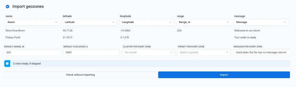
Map each CSV column to a geozone field. Under each column header, open the dropdown and choose the field that column should fill:
- If Pushwoosh matched the header wrong, pick the correct field in the dropdown.
- Set a column to **Do not import** to ignore it.
- Map **Name**, **Latitude**, and **Longitude** at minimum.
- Map **Range, m**, **Cooldown, s**, **Message**, **Cluster code**, or **Preset code** when those columns are in the file.
Set defaults for values the file does not supply:
- **Default range, m** and **Default cooldown, s.** Used when the file has no range or cooldown column, or the cell is empty (as with "Pickup Point" in the example).
- **Cluster for every zone.** Pick a cluster, or leave **No cluster**.
- **Preset for every zone.** Optional push preset for every row that needs one.
- **Message for every zone.** Used when the file has no message column. Rows that already have a message keep their own text.
4. Check the ready and skipped counts (for example **2 rows ready, 0 skipped**). Fix mapping or the spreadsheet if needed, then click **Check without importing**. Pushwoosh validates the whole file without creating geozones. [Rejected rows](#why-a-row-gets-skipped) come back with the line number and the reason, so you can fix the spreadsheet and try again with nothing left half-written.
5. When the check looks right, click **Import**. Geozones are created in batches. The result screen reports how many were created and which rows failed.
Importing the same file twice creates a second copy of every geozone: names are not unique. To correct a mistake, delete the geozones you imported and import the corrected file.
### Why a row gets skipped
During check or import, rows that cannot be read are listed with their line number and skipped. The rest are still imported. A row is skipped when:
- the name is empty
- the latitude or the longitude is not a number, or falls outside the range given in the table above
- the range is not a number, or falls outside 50 to 100,000 m
- the cooldown is not a number, or falls outside 60 to 3,596,400 s
- the row ends up with neither a message nor a preset
To create geozones from your own system rather than a file, use the [addGeoZone API method](/developer/api-reference/geozones/#addgeozone).
 2. Select your CSV file.
3. Map columns and set defaults on the **Import geozones** screen.
Map each CSV column to a geozone field. Under each column header, open the dropdown and choose the field that column should fill:
- If Pushwoosh matched the header wrong, pick the correct field in the dropdown.
- Set a column to **Do not import** to ignore it.
- Map **Name**, **Latitude**, and **Longitude** at minimum.
- Map **Range, m**, **Cooldown, s**, **Message**, **Cluster code**, or **Preset code** when those columns are in the file.
Set defaults for values the file does not supply:
- **Default range, m** and **Default cooldown, s.** Used when the file has no range or cooldown column, or the cell is empty (as with "Pickup Point" in the example).
- **Cluster for every zone.** Pick a cluster, or leave **No cluster**.
- **Preset for every zone.** Optional push preset for every row that needs one.
- **Message for every zone.** Used when the file has no message column. Rows that already have a message keep their own text.
2. Select your CSV file.
3. Map columns and set defaults on the **Import geozones** screen.
Map each CSV column to a geozone field. Under each column header, open the dropdown and choose the field that column should fill:
- If Pushwoosh matched the header wrong, pick the correct field in the dropdown.
- Set a column to **Do not import** to ignore it.
- Map **Name**, **Latitude**, and **Longitude** at minimum.
- Map **Range, m**, **Cooldown, s**, **Message**, **Cluster code**, or **Preset code** when those columns are in the file.
Set defaults for values the file does not supply:
- **Default range, m** and **Default cooldown, s.** Used when the file has no range or cooldown column, or the cell is empty (as with "Pickup Point" in the example).
- **Cluster for every zone.** Pick a cluster, or leave **No cluster**.
- **Preset for every zone.** Optional push preset for every row that needs one.
- **Message for every zone.** Used when the file has no message column. Rows that already have a message keep their own text.
 4. Check the ready and skipped counts (for example **2 rows ready, 0 skipped**). Fix mapping or the spreadsheet if needed, then click **Check without importing**. Pushwoosh validates the whole file without creating geozones. [Rejected rows](#why-a-row-gets-skipped) come back with the line number and the reason, so you can fix the spreadsheet and try again with nothing left half-written.
5. When the check looks right, click **Import**. Geozones are created in batches. The result screen reports how many were created and which rows failed.
4. Check the ready and skipped counts (for example **2 rows ready, 0 skipped**). Fix mapping or the spreadsheet if needed, then click **Check without importing**. Pushwoosh validates the whole file without creating geozones. [Rejected rows](#why-a-row-gets-skipped) come back with the line number and the reason, so you can fix the spreadsheet and try again with nothing left half-written.
5. When the check looks right, click **Import**. Geozones are created in batches. The result screen reports how many were created and which rows failed.
 Importing the same file twice creates a second copy of every geozone: names are not unique. To correct a mistake, delete the geozones you imported and import the corrected file.
### Why a row gets skipped
During check or import, rows that cannot be read are listed with their line number and skipped. The rest are still imported. A row is skipped when:
- the name is empty
- the latitude or the longitude is not a number, or falls outside the range given in the table above
- the range is not a number, or falls outside 50 to 100,000 m
- the cooldown is not a number, or falls outside 60 to 3,596,400 s
- the row ends up with neither a message nor a preset
To create geozones from your own system rather than a file, use the [addGeoZone API method](/developer/api-reference/geozones/#addgeozone).
Importing the same file twice creates a second copy of every geozone: names are not unique. To correct a mistake, delete the geozones you imported and import the corrected file.
### Why a row gets skipped
During check or import, rows that cannot be read are listed with their line number and skipped. The rest are still imported. A row is skipped when:
- the name is empty
- the latitude or the longitude is not a number, or falls outside the range given in the table above
- the range is not a number, or falls outside 50 to 100,000 m
- the cooldown is not a number, or falls outside 60 to 3,596,400 s
- the row ends up with neither a message nor a preset
To create geozones from your own system rather than a file, use the [addGeoZone API method](/developer/api-reference/geozones/#addgeozone).